Data from Selected U.S. Geological Survey National Stream Water-Quality
Monitoring Networks (WQN)
USGS Digital Data Series DDS-37
By Richard B. Alexander, James R. Slack, Amy S. Ludtke, Kathleen K. Fitzgerald,
and Terry L. Schertz
Water-Quality and Streamflow Data
The water-quality and streamflow data sets are available for 679 locations
in the United States including 63 HBN
stations from 1962 to 1995 and 618 NASQAN
stations from 1973 to 1995 (two stations belonged to both
networks during the period of operations; also the number of network stations
operated in any year periodically changed).
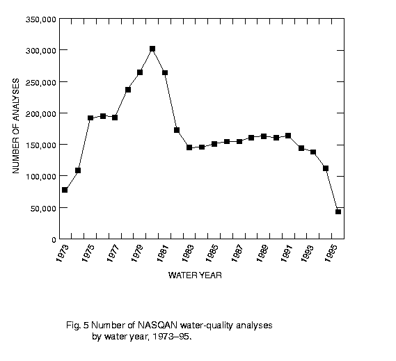
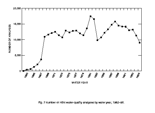
Note that the number of water-quality
analyses conducted in NASQAN and
HBN has changed over time
because of changes in sampling frequency and the number of stations and
water constituents (see the accompanying
Open-File Report 96-337 for details).
Supporting information
identifies and describes the water-quality and streamflow stations and
watersheds, water-quality constituents, and the methods, remarks, laboratories,
sample-collection agencies, and the laboratory
measurement accuracy associated with the water-quality data.
WQN water-quality and streamflow data can be obtained for stations in a
specific water-resources region by first selecting the corresponding
region number from the list below. The organization of the data files
and file formats are described in a subsequent section.
The Water Resources Council developed a
hierarchial classification of hydrologic drainage basins in the United
States of which the first level of classification consists of 21
water-resources regions as shown below.
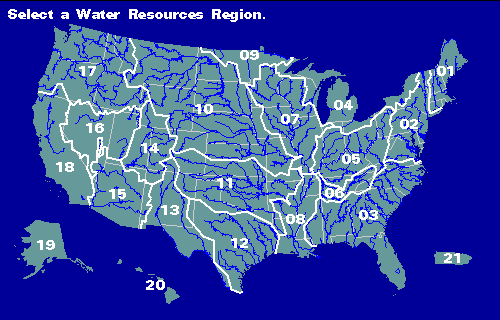
The gray lines are state lines, the blue lines are major rivers, and the white
lines are water-resources region boundary lines.
Region 01 New England
Region 02 Mid-Atlantic
Region 03 South Atlantic-Gulf
Region 04 Great Lakes
Region 05 Ohio
Region 06 Tennessee
Region 07 Upper Mississippi
Region 08 Lower Mississippi
Region 09 Souris-Red-Rainy
Region 10 Missouri
Region 11 Arkansas-White-Red
Region 12 Texas-Gulf
Region 13 Rio Grande
Region 14 Upper Colorado
Region 15 Lower Colorado
Region 16 Great Basin
Region 17 Pacific Northwest
Region 18 California
Region 19 Alaska
Region 20 Hawaii
Region 21 Caribbean
Organization of the Data Files
Within each of the 21 water-resources regions, the water-quality
and streamflow data are organized in separate station and parameter
files. The name of each file is ssssssss.ttt where
ssssssss is the 8-digit USGS station number, and ttt is:
ALK for alkalinity, bicarbonate, and carbonate parameters,
BIO for biological parameters,
DMV for daily mean values of streamflow,
MAJ for major dissolved ions,
MT1 for dissolved and total trace-element parameters,
MT2 for dissolved and total trace-element parameters,
MT3 for dissolved and total trace-element parameters,
MT4 for dissolved and total trace-element parameters,
NUT for nutrients, suspended sediment, and organic carbon,
PHY for physical/field parameters including instantaneous
flow, and
RAD for radiochemical parameters.
File Formats
See the WQ.FMT file for details
of the water-quality file layout.
See the DMV.FMT file for details
of the daily mean streamflow file layout.
Within each file there is one record for each date and
time sampled except for the daily mean streamflow values
where there is one record for each day of the month (31 records
to a calendar year). The records are sorted by date, time, and
ending date (which may be present for some biological data).
The instantaneous streamflow recorded at the time of water-quality
sampling is stored in each of the water-quality data files, and
is available for use in cases where water-quality and streamflow pairs
are required (e.g., correlations between water-quality and flow).
Supporting Water-Quality and Streamflow Information
Return to First Page
The pathname for this page is <html/wqn/wq/wq.htm>
Last modified: Thu Mar 8 17:28:40 EST 2001